
Page 1098 - Proceedings Collega2023
P. 1098
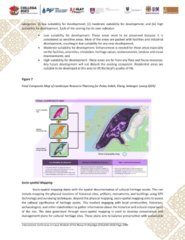
categories: (i) low suitability for development; (ii) moderate suitability for development; and (iii) high
               suitability for development. Each of the scoring has its own indicator:

                          •  Low  suitability  for  development:  These  areas  need  to  be  preserved  because  it  is
                              considered as sensitive areas. Most of the areas are packed with facilities and industrial
                              development, resulting in low suitability for any new development;
                          •  Moderate suitability for development: Enhancement is needed for these areas especially
                              on the facilities, amenities, circulation, heritage values, socioeconomic, landuse and visual
                              improvements; and
                          •  High suitability for development: These areas are far from any flora and fauna resources.
                              Any future development will not disturb the existing ecosystem. Residential areas are
                              suitable to be developed at this area to lift the local’s quality of life.


               Figure 7

               Final Composite Map of Landscape Resource Planning for Pulau Indah, Klang, Selangor (using QGIS)


               Socio-spatial Mapping

                       Socio-spatial mapping starts with the spatial documentation of cultural heritage assets. This can
               include mapping the physical locations of historical sites, artifacts, monuments, and buildings using GPS
               technology and surveying techniques. Beyond the physical mapping, socio-spatial mapping aims to assess
               the cultural significance of heritage assets. This involves engaging with local communities, historians,
               archaeologists, and other stakeholders to gather information about the historical and cultural importance
               of  the  site.  The  data  generated  through  socio-spatial  mapping  is  used  to  develop  conservation  and
               management plans for cultural heritage sites. These plans aim to balance preservation with sustainable


               International Conference on Local Wisdom of the Malay Archipelago (COLLEGA 2023) Page 1085