
Page 1099 - Proceedings Collega2023
P. 1099
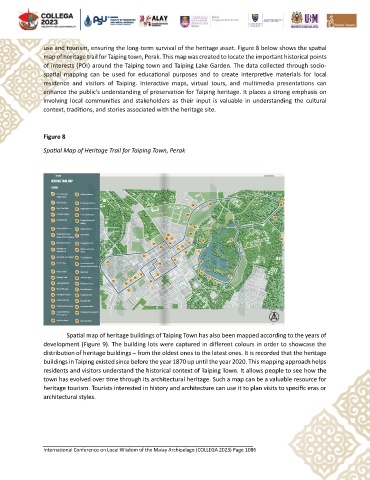
use and tourism, ensuring the long-term survival of the heritage asset. Figure 8 below shows the spatial
               map of heritage trail for Taiping town, Perak. This map was created to locate the important historical points
               of interests (POI) around the Taiping town and Taiping Lake Garden. The data collected through socio-
               spatial  mapping  can  be  used  for  educational  purposes  and  to  create  interpretive  materials  for  local
               residence  and  visitors  of  Taiping.  Interactive  maps,  virtual  tours,  and  multimedia  presentations  can
               enhance the public's understanding of preservation for Taiping heritage. It places a strong emphasis on
               involving local  communities  and  stakeholders  as  their  input  is  valuable  in  understanding  the  cultural
               context, traditions, and stories associated with the heritage site.


               Figure 8
               Spatial Map of Heritage Trail for Taiping Town, Perak


                        Spatial map of heritage buildings of Taiping Town has also been mapped according to the years of
               development (Figure 9). The building lots were captured in different colours in order to showcase the
               distribution of heritage buildings – from the oldest ones to the latest ones. It is recorded that the heritage
               buildings in Taiping existed since before the year 1870 up until the year 2020. This mapping approach helps
               residents and visitors understand the historical context of Taiping Town. It allows people to see how the
               town has evolved over time through its architectural heritage. Such a map can be a valuable resource for
               heritage tourism. Tourists interested in history and architecture can use it to plan visits to specific eras or
               architectural styles.


               International Conference on Local Wisdom of the Malay Archipelago (COLLEGA 2023) Page 1086