
Page 1093 - Proceedings Collega2023
P. 1093
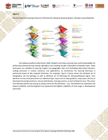
Figure 1

               Overlay Maps of Landscape Resource Attributes for Selayang-Rawang Region, Selangor (using MapInfo)


                       GIS software platforms like ArcGIS, QGIS, MapInfo and others provide tools and functionalities for
               performing composite map overlay operations and creating visually informative composite maps. These
               techniques are valuable for gaining insights into geographic data and facilitating data-driven decision-
               making  processes  in  various  industries  and  applications.  As  mentioned,  the  layering  technique  is
               performed based on the assigned attributes. For example, Figure 2 below shows  the attribute set of
               topography,  soil  and  geology,  as  well  as attribute  set  of  hydrology  for  Selayang-Rawang  region.  Each
               attribute set has a few parameters on individual layer maps such as slope gradient, slope types, density of
               development and groundcover, natural waterbodies, drainage system, as well as flood risk area. The colour
               hue intensity depicts the scoring or rating criteria for the attributes – e.g.: the darkest hue represents the
               lowest suitability, and the brightest hue represents the highest suitability of land usage or development
               potentials.


               International Conference on Local Wisdom of the Malay Archipelago (COLLEGA 2023) Page 1080